|

|
|
| Product Information: | ||
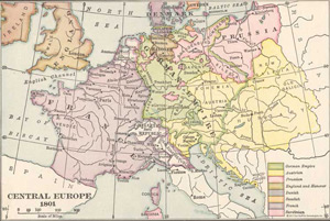
| Details: | Central Europe in 1801; by Philip Van Ness Myers ; 1 pp; Map; Published: 1923; 10.5x14; Item # FS015 This is a full color reproduction of an 1801 map of Central Europe. Originally published in General History by Philip Van Ness Myers. Areas include: Austria, Batavian Republic, Bohemia, Brandenburg, Cisalpine Republic, Denmark, England, France, German Empire, Hanover, Helvetic Republic, Hungary, Ireland, Ligurian Republic, Mecklenburg, Pomerania, Prussia, Sardinia, Saxony, Silesia, Sweden, and much more. All of these maps come in a protective, archival safe sleeve. |
|